|
|
| (28 intermediate revisions by 4 users not shown) |
| Line 2: |
Line 2: |
| | Why not edit me? | | Why not edit me? |
| | llololdldldldldldl | | llololdldldldldldl |
| | + | <!--Some CSS formatting from https://www.w3schools.com/css/css_text.asp:--> |
| | + | <p style="color:darkred">Co</p> |
| | + | <p style="color:#98CDE3">ou</p> |
| | + | <p style="color:rgb(200,100,0)">rs</p> |
| | + | <p style="text-decoration-line:underline;text-decoration-style:wavy;background-color:yellow;color:lightgreen;letter-spacing:10px;text-shadow:2px 2px 3px blue;font-family:Cursive;font-size:30px"><b><i><u><s>& more</s></u></i></b></p> |
| | + | |
| | + | [[Category:Turdus|Turdus merula]] |
| | | | |
| | ==Test== | | ==Test== |
| Line 219: |
Line 226: |
| | | | |
| | ==video test== | | ==video test== |
| − | {{Video|http://www.birdforum.tv/members/action/viewvideo/1200/Song_Sparrow_singing_away/|Copelab (mostly demonstrating the song)}} | + | {{VSearch|"Melospiza melodia" {{!}} "Song Sparrow"}} |
| | | | |
| | == test gif == | | == test gif == |
| Line 251: |
Line 258: |
| | | | |
| | | | |
| | + | =='''Beta Category:Indonesia Page'''== |
| | | | |
| − | | + | [[Image:2-8-2015 054.jpg|thumb|550px|right|Samosir island and Lake Toba, 1974 <br />Photo by {{user|Tiger1|Tiger1}}]] |
| − | == Beta MST ==
| |
| − | [[Image:mstmap.jpg|thumb|550px|right|Mountains to Sea Trail Map - Click map for larger image<br />Photo © by {{user||Friends of Mountains to Sea Trail – Curtis Belyea, Map Maker- Used with their kind permission<sup>[[#References|[1]]]</sup> }}<br />Raleigh [[North Carolina]] March 28, 2020]] | |
| − | | |
| | ==Overview== | | ==Overview== |
| − | The Mountains to Sea Trail is an ambitious undertaking of significant proportions by groups of dedicated volunteers, sponsors, and the State of [[North Carolina]].
| + | Indonesia, known formally as the Republic of Indonesia, is an island nation composed of a total of 17, 508 islands extending 5,150 km/3,200 miles between the Pacific Ocean and the Indian Ocean occupying an area between Asia and [[Australia]]. |
| | | | |
| − | When completed, it will extend for approximately 1175 miles between two widely differing points. While making this hike across the state, it will come into contact with 4 United States National Parks, 3 National Forests, 2 Wilderness Areas, 3 Wilderness Study Areas, 2 National Wildlife Refuges, 10 North Carolina State Parks, 4 State Game Lands, 1 State Forest, and 1 State Historic Site.
| + | The country is made up of five major islands and approximately 30 smaller groups of islands. However, only approximately 6,000 of those islands are inhabited. |
| | | | |
| − | One point, in the mountains of [[Western North Carolina]], is at <sup>[[#Maps|[Map 1]]]</sup>Clingman’s Dome<sup>[[#External Links|[5]]]</sup> with it’s 6,643 feet above sea level elevation, and the other is at a rather large sand dune, <sup>[[#Maps|[Map 2]]]</sup>Jockey’s Ridge<sup>[[#External Links|[6]]]</sup>, at an elevation of 100 feet above sea level, on the [[Outer Banks]].
| + | It is a country of many mountains, some of which are over 4000 metres/13,123 feet. A significant percentage of them are active volcanoes. Some of the habitats here are tropical rainforests, jungles, and swampy mangrove areas. <sup>[[#References|[1]]]</sup> |
| − |
| |
| − | Thus the trail will literally run from the mountains to the sea, hence its name.
| |
| | | | |
| − | The MST will be a combination of actual trails, country back roads, and an option for paddling part of the route. It will wind through mountain habitat with the birds, wildlife, and plant life of the mountains. Then down into, and across, the [[Piedmont Region of North Carolina]] with its accompanying species of birds and wildlife. Then finally coming into and across the coastal region of [[Eastern North Carolina]] with its sandy soil, pine forests, lowlands, and waterways before crossing over the sounds and onto the Outer Banks.
| + | ==Islands of Indonesia== |
| | + | ===Major Island Groups=== |
| | + | Indonesia has 5 major, or main, island groups.<sup>[[#References|[1]]]</sup> |
| | + | ====Sumatra==== |
| | + | Sumatra comprises 473,606 sq. km/182,860 sq miles in area. |
| | + | ====Java / Madura==== |
| | + | Java / Madura comprises 132,107sq. km/51,006 sq miles in area. |
| | | | |
| − | The Mountains to Sea Trail will combine all of this into a fun and informative cross-section of what North Carolina has to offer when it comes to birds and birding, combined with a great new addition to hiking in North Carolina.
| + | West Java is the home of the [[Gede Pangrango National Park]] with all it has to offer. |
| | + | ====Kalimantan==== |
| | + | Kalimantan with 539,460 sq. km/20,8286 sq miles in area, makes up 2/3 of the island of Borneo. |
| | + | ====Sulawesi==== |
| | + | Sulawesi comprises 189,216 sq. km/73,056 sq miles in area. |
| | + | ====Irian Jaya - Maluku Islands==== |
| | + | Irian Jaya comprises 421,981 sq. km/162927 sq miles in area, is a part of the island of [[New Guinea]]. |
| | | | |
| − | ==Birds== | + | == Spotted Pardalote Sex Comparison Composite Test Page == |
| − | A listing of birding potential along the Mountains to the Sea Trail in [[North Carolina]] could easily be as long as the trail itself. So since the trail goes through each of the four primary regions of the state, let’s try it this way. Click on the name and link of the region in which you are interested. Or, if you want, all of them, and read what’s already there in those articles for the categories of '''“Notable Species"''', '''“Rarities”''', and''' “Birds You Might See”''' checklist.
| |
| | | | |
| − | As the trail name implies, let's first start in the mountains.
| + | [[File:Spotted_Pardalote_Sex-Comparison_CRCLS.jpg|thumb|350px|right|Note spot color on the heads.<br />Composite of two ChrisCharles Images<br />Photo © by {{user|ChrisCharles|ChrisCharles}}<br /> Chatswood New South Wales, [[Australia]]<br /> 3 September 2006]] |
| | + | The female and male of this species can be determined, in part, by the color of the spots on their heads. |
| | | | |
| − | ====Western North Carolina====
| + | The female has yellow/creamy spots while the male has white spots. |
| − | First look at [[Western North Carolina]]. Enjoy that region to your heart’s content as the trail winds its way through a rich and complex natural landscape. Maybe, just maybe you will get to see a majestic [[Bald Eagle]] as it soars above the mountains and forests. After all, it has been seen in all the counties in this region. If not, perhaps a [[Golden Eagle]] or [[Canada Goose]] will be your lucky check on your life list. Habitat varies here. Be ready for what comes your way. When ready, move on to the next leg of your journey.
| |
| | | | |
| − | ====Piedmont Region of North Carolina====
| + | See the composite image for further clarification. |
| − | Further east you'll come into the more agricultural lands of the [[Piedmont Region of North Carolina]]. Take in as many of the species of birds inhabiting the northern part of this region as you can as you walk this part of the trail. The [[Northern Cardinal]] is always a good possibility as is the [[Red-Winged Blackbird]] and [[Double-crested Cormorant]]. As you check off your last sighting here, know you have more awaiting you just down the trail.
| |
| | | | |
| − | ====Eastern North Carolina====
| |
| − | Notice, as you come into the [[Eastern North Carolina]] region, you will begin to see an increasingly flatter, changing habitat indicative of a coastal plain, such as this. As you travel further, enjoy the changing landscape and different species of birds you may see here. One of the more common species here has been the [[Tundra Swan]]. Don’t rule out a [[Ring-billed Gull]] or a [[Snow Goose]] while you’re here. But, before you feel it’s time to conclude your journey, be sure to take a ride across one of the sounds and waterways you will probably see. Even more, awaits you on the other side.
| |
| | | | |
| − | ====Outer Banks====
| |
| − | As you arrive on the [[Outer Banks]] notice your landscape will change to a region of sandy soil, sand dunes, marshes, and shorebirds, in addition to a myriad of wildlife. Maybe it will be the rarely seen [[American Coot]], or the often seen [[Laughing Gull]] or [[Bonaparte’s Gull]]. Opportunities abound in this part of the state.
| |
| − | Along this trail, as you come to the Atlantic Ocean, you will have covered, and discovered, a very large portion of what the state has to offer in the way of bird species and wildlife, as the trail name implies, from the Mountains to the Sea.
| |
| | | | |
| − | ==Other Wildlife== | + | ==References== |
| − | Wildlife, just as in thinking about birds, is largely dependent on which region of the state you happen to find yourself in. Your possibilities could vary from black bears and elk in Western North Carolina to deer and wild turkeys in the Piedmont Region, to more bears, more deer in Eastern North Carolina. Add into that a significant variety of small mammals from foxes and rabbits to reptiles across all the various regions. Just be careful, respect what you see, and you shouldn’t have any problems.
| + | #Embassy of the Republic of Indonesia - https://www.embassyofindonesia.org/index.php/basic-facts/ |
| | | | |
| − | ==Site Information==
| |
| − | ===History and Use===
| |
| − | As far as history goes, the Mountains to the Sea Trail is a relative newcomer. It was first proposed in 1977 by Howard Lee who was then the Secretary of the North Carolina Department of Natural Resources and Community Development.
| |
| | | | |
| − | In 2000, it became a part of the North Carolina State Parks system as a State Trail
| + | {{ref}} |
| | | | |
| − | It grew significantly in 2017 when the State Legislature approved a major addition in southeastern North Carolina, and continues to grow, even now, with new trail sections being built. These new sections are then put into use to take the place of some of the trail which had been routed along back, country roads.
| + | ==External Links== |
| − | An awful lot of the work is being done by a dedicated group of people who provide volunteer labor, use of private land for trails, donations, fundraising, and corporate sponsors. Should you choose to become a part of all this, you will find plenty of information on the trail’s and trail supporter’s respective websites.
| + | ==Maps== |
| − | | + | #[https://goo.gl/maps/WXc8CZ7ShjGR6BXb7 Indonesia on Google Maps] |
| − | ===Areas of Interest=== | |
| − | Just like trying to pin down notable species of birds in a state like North Carolina, with it’s widely varying regions, is hard, so too is it problematic when trying to define areas of interest.
| |
| − | | |
| − | One of the features of the Mountains to Sea Trail, and one that makes it such a great spot for potentially good birding sites, is the number of protected natural areas it passes through. Altogether, MST connects, in one form or another, with 30 protected areas distributed across all areas, from the mountains to sea..
| |
| − | | |
| − | So, in an effort to be as fair as is reasonably possible, let’s revisit each region separately. As we make our trek, click on the regional names for more information and keep your maps on the North Carolina State Trails<sup>[[#External Links|[2]]]</sup> and Friends of MST<sup>[[#External Links|[1]]]</sup> websites handy for reference. The Friends of the Mountain to Seas Trail site, with its extensive information on the trail and its segments will be very valuable.
| |
| − | | |
| − | Since the MST is, as its name implies, a mountain to the sea trail, we’ll start with Western North Carolina.
| |
| − | | |
| − | ====Western North Carolina====
| |
| − | [[Western North Carolina]], or as it’s frequently known WNC, is, by its very nature, a place of interest. There is so, so much to see and do in this part of the state that the problem isn’t finding something to do, but deciding which one to choose. Nature abounds in almost any corner of WNC. Birds of so many species, wildlife of every persuasion, and a multitude of places to enjoy it all. You can camp and enjoy it. You can day-trip and picnic. You can hike and enjoy it. And don’t forget the Appalachian Trail runs through here and connects with Mountains to Sea Trail in the Clingman’s Dome<sup>[[#External Links|[5]]]</sup>area. Another icon of WNC is the [[Blue Ridge Parkway]] as is the Great Smoky Mountains National Park. All intertwined with birds, wildlife, and nature.
| |
| − | =====Protected Areas in Western North Carolina=====
| |
| − | In Western North Carolina, they are the Great Smoky Mountains National Park, [[Blue Ridge Parkway]], Nantahala National Forest, Pisgah National Forest, Middle Prong Wilderness Area, Linville Gorge Wilderness Area, Craggy Mountains Wilderness Study Area, Harper Creek Wilderness Study Area, Lost Cove Wilderness Study Area, Mount Mitchell State Park, and Grandfather Mountain State Park.
| |
| − | | |
| − | ====Piedmont Region of North Carolina====
| |
| − | As a visitor to [[North Carolina]] comes down from the mountains; they enter the [[Piedmont Region of North Carolina]]. The streams that might have been trickles in the mountains become larger rivers and the rivers widen into lakes. But the opportunities for birding and enjoyment of nature still abound. The trails, both hiking and paddling, lead you to enjoyable sights. The MST crosses the northern portion of this region as it makes its way east and in so doing takes you at, or near, Pilot Mountain State Park and Hanging Rock State Park before turning somewhat southeast traveling at, or near, William B. Umstead State Park. You will have had the opportunity to see a cross-section of the bird species and wildlife the middle of the state has to offer as you prepare to enter into Eastern North Carolina.
| |
| − | =====Protected Areas in the Piedmont Region of North Carolina=====
| |
| − | Crossing the Piedmont Region of North Carolina, MST contacts the Stone Mountain State Park, Pilot Mountain State Park, Hanging Rock State Park, Eno River State Park, Falls Lake State Park, and Butner-Falls of Neuse Game Lands.
| |
| − | | |
| − | ====Eastern North Carolina====
| |
| − | Crossing into [[Eastern North Carolina]], the grade will begin to level out the further east you go and the habitat will start changing to a sandy soil with stands of increasingly more prevalent pines and other similar trees. Birds and wildlife will start to change. Waterways and wetlands may become more common. There will be an increasing opportunity for game lands and wildlife reserves. When you get near Smithfield, you are at the point of deciding if you want to take the MST's alternate paddling route on the Neuse or continue on the trail. Either choice is sure to be a unique opportunity to spot some new bird species. Should you choose to continue on the trail, consult your trail guide for other opportunities.
| |
| − | =====Protected Areas in Eastern North Carolina=====
| |
| − | In Eastern North Carolina the protected natural areas the MST will show you are the Moores Creek National Battlefield, Croatan National Forest, Cedar Island National Wildlife Refuge, Pea Island National Wildlife Refuge, Jones Lake State Park, Singletary Lake State Park, Suggs Mill Pond State Park, Stones Creek State Park, Holly Shelter State Park, Bladen Lakes State Forest, and the Bentonville Battlefield State Historic Site.
| |
| − | | |
| − | As you come to the large sounds and rivers on your horizon, prepare to cross to your fourth and final segment of this great trek.
| |
| − | | |
| − | ====Outer Banks====
| |
| − | As you step foot onto the sand of the [[Outer Banks]], prepare yourself to take in some vistas and experiences similar to what some of the initial settlers to the then New World might have seen. Birds of such a variety of species, both large and small, swimming and walking as to astonish you. Break out your field guides, binoculars, and get ready to be amazed. And while you are doing that, be aware of your surroundings. You are, after all, in the land where pirates might have trod. You might see still functioning lighthouses, experience herds of wild horses rumored to have been shipwrecked here from Spanish explorer’s vessels, and see some of the most natural lands still remaining.
| |
| − | =====Protected Areas on the Outer Banks=====
| |
| − | As you come to the far eastern Outer Banks portion of the MST, there is the Cape Hatteras National Seashore and Jockey’s Ridge State Park where it meets the Atlantic Ocean completing its Mountains to Sea journey,
| |
| − | | |
| − | =====Wrap-Up=====
| |
| − | Should you have hiked the entire length, or any portion thereof, you will have passed through some notable natural areas of North Carolina and experienced areas with fantastic birding potential.
| |
| | | | |
| − | Check out the wild ponies, lighthouse, and historic town at Ocracoke. Cape Hatteras area affords great opportunities for all kinds of birds.
| |
| − | See where powered flight was first attempted by the Wright Brothers at Kill Devils Hill. And before you turn toward home, check on the wild horses of Corolla.
| |
| | | | |
| − | All in all, you will be coming to the end of what has to have been a great trip through a great state on a great North Carolina trail called the Mountains to Sea Trail.
| |
| | | | |
| − | Hope you have enjoyed the trip.
| + | {{GSearch|"Indonesia" {{!}} "Borneo"}} |
| | + | <br /> |
| | + | {{VSearch|"Indonesia" {{!}} "Borneo"}} |
| | | | |
| − | ===Access and Facilities===
| |
| − | With the MST such a long trail covering the whole state from west to east, the best way to give you directions to it is to suggest you go to the Friends of the MST site and avail yourself of a guide to the portion of the trail you are interested in and then consult a road map or an online map service for specific directions.
| |
| | | | |
| − | However, once you are on the trail, there will be marks to give you direction. This is especially important should you happen to find yourself on a section where two trails are on the same path and one of them veers a different way. Familiarize yourself with those for the MST before you go and pay attention after you get there.
| + | [[Category:Asia]] [[Category:Videos]] |
| | | | |
| − | ===Contact Details=== | + | == Experiment With Dual Gsearch Coding == |
| − | Due to the large numbers of people involved with the MST, the best way to contact the applicable stakeholders is to suggest you go to one, or more, of the websites associated with the trail for information on how to contact the person involved with what you are asking about. There are a lot of means of contact to be had there.
| |
| | | | |
| − | ===References===
| + | <br /> |
| − | #Map provided courtesy of Friends of the Mountains-to-Sea Trail, map by Curtis Belyea
| + | {{GSearch|"Khijadiya" {{!}} "Khijadia"}} |
| − | ==External Links==
| + | <br /> |
| − | #[https://trails.nc.gov/state-trails/mountains-sea-state-trail Mountains to Sea Trail on State Trails website]
| + | {{VSearch|"Khijadiya" {{!}} "Khijadia"}} |
| − | #[https://mountainstoseatrail.org/the-trail/ Friends of Mountains to Sea Trail]
| |
| − | #[https://www.nps.gov/index.htm/ United States National Park Service]
| |
| − | #[https://www.ncparks.gov// North Carolina State Parks]
| |
| − | #[https://www.nps.gov/grsm/planyourvisit/clingmansdome.htm/ Clingman's Dome on US National Park Service site]
| |
| − | #[https://www.ncparks.gov/jockeys-ridge-state-park/home/ Jockey's Ridge State Park]
| |
| − | ====Maps====
| |
| − | #[https://goo.gl/maps/2kDEGDqMUURu7q3K8 Clingman's Dome on Google Maps]
| |
| − | #[https://goo.gl/maps/Mg7xeLxYXSJPMHQW7 Jockey's Ridge State Park on Google Maps]
| |
Edit Me!
Why not edit me?
llololdldldldldldl
Co
ou
rs
& more
Test
Testing! Steve 18:53, 20 August 2007 (UTC)
Tables
| Common Jay,
|
Woodcock,
|
Scaup,
|
Pochard,
|
Goldeneye,
|
Shag,
|
| Kittiwake,
|
Marsh Harrier,
|
Sparrowhawk,
|
Moorhen,
|
Avocet,
|
Oystercatcher,
|
| Golden Plover,
|
Greenshank,
|
Curlew,
|
Woodcock,
|
Turnstone,
|
Kittiwake,
|
| Wood Pigeon,
|
Collared Dove,
|
Turtle Dove,
|
Hoopoe,
|
Wryneck,
|
House Martin
|
With Borders
Borders and Spacing
| Common Jay,
|
Woodcock,
|
Scaup,
|
Pochard,
|
Goldeneye,
|
Shag,
|
| Kittiwake,
|
Marsh Harrier,
|
Sparrowhawk,
|
Moorhen,
|
Avocet,
|
Oystercatcher,
|
| Golden Plover,
|
Greenshank,
|
Curlew,
|
Woodcock,
|
Turnstone,
|
Kittiwake,
|
| Wood Pigeon,
|
Collared Dove,
|
Turtle Dove,
|
Hoopoe,
|
Wryneck,
|
House Martin
|
Cell Spacing Without Borders
| Common Jay,
|
Woodcock,
|
Scaup,
|
Pochard,
|
Goldeneye,
|
Shag,
|
| Kittiwake,
|
Marsh Harrier,
|
Sparrowhawk,
|
Moorhen,
|
Avocet,
|
Oystercatcher,
|
| Golden Plover,
|
Greenshank,
|
Curlew,
|
Woodcock,
|
Turnstone,
|
Kittiwake,
|
| Wood Pigeon,
|
Collared Dove,
|
Turtle Dove,
|
Hoopoe,
|
Wryneck,
|
House Martin
|
No borders with check boxes
==
Last edited by LarryUsselman-34099 17:41, 2 October 2007 (UTC)
The Sandbox (Subsahara mythica) is a rare moth of the Sahel region of Africa. It is of course mythical!
video test
test gif
This is a test if this type of image will work in Opus. It seems to do, but only if the part of "thumbs" is omitted from our usual image code. Image in original context can be seen here.
Collared Scops Owl
A resident breeder in the Indian sub continent, South Asia right into China, the Collared Scops Owl (Ottus lettia), family Stygidae is woodland Owl. It seems to be different enough form Indian Scops Owl Ottus bakkomoena, to merit a separate species rank. It has small éars'- (head tufts) and has s buffish body with streaks.
The facial disc is whitish or buff, and the eyes are orange or brown. There is a buff neckband. Sexes are similar. The flight is deeply undulating.
This species is nocturnal but it can often be located by the small birds that mob it while it is roosting in a tree. It feeds mainly on insects. The call is a quiet goog gook.
This species is chiefly found in northern India and is replaced by the very similar looking Oriental Scops Owl Otus sunia (recently split) towards the south of its range. It is very similar also to the slightly smaller Indian Scops Owl, O. bakkamoena. They are most easily separated in the field by their calls. (source Per. Obs, Wikipedia).
'Italic text'
Alternate voice recording coding used by Morlan in the wren page.
Song Clip Recording © by Joseph Morlan. Rosyth, Fife, Scotland, UK, 03 August 2018
Recommended Citation
BirdForum Opus contributors. (2020) Eurasian Collared Dove (Streptopelia decaocto). In: BirdForum, the forum for wild bird birds and birding. Retrieved 6 March 2020, from https://www.birdforum.net/opus/Eurasian_Collared_Dove
References
Lepage D. ({{subst:CURRENTYEAR}}) {{subst:PAGENAMEE}} in [http://www.bsc-eoc.org/avibase/ Avibase - The World Bird Database]. Retrieved {{subst:CURRENTDAY}} {{subst:CURRENTMONTHNAMEGEN}} {{subst:CURRENTYEAR}}
Lepage D. (2020) Ref-Avibase in Avibase - The World Bird Database. Retrieved 13August 2020
The Definition of Migration (in my words)
The definition of migration (in my words) is when an organism or group of organisms travel a distance to another part of the world, for one reason or another. Many of these organisms, such as many waterfowl, have "pit stops" on the way to their destination, which make good places for making observations on those animals.
Beta Category:Indonesia Page

Samosir island and Lake Toba, 1974
Photo by
Tiger1Overview
Indonesia, known formally as the Republic of Indonesia, is an island nation composed of a total of 17, 508 islands extending 5,150 km/3,200 miles between the Pacific Ocean and the Indian Ocean occupying an area between Asia and Australia.
The country is made up of five major islands and approximately 30 smaller groups of islands. However, only approximately 6,000 of those islands are inhabited.
It is a country of many mountains, some of which are over 4000 metres/13,123 feet. A significant percentage of them are active volcanoes. Some of the habitats here are tropical rainforests, jungles, and swampy mangrove areas. [1]
Islands of Indonesia
Major Island Groups
Indonesia has 5 major, or main, island groups.[1]
Sumatra
Sumatra comprises 473,606 sq. km/182,860 sq miles in area.
Java / Madura
Java / Madura comprises 132,107sq. km/51,006 sq miles in area.
West Java is the home of the Gede Pangrango National Park with all it has to offer.
Kalimantan
Kalimantan with 539,460 sq. km/20,8286 sq miles in area, makes up 2/3 of the island of Borneo.
Sulawesi
Sulawesi comprises 189,216 sq. km/73,056 sq miles in area.
Irian Jaya - Maluku Islands
Irian Jaya comprises 421,981 sq. km/162927 sq miles in area, is a part of the island of New Guinea.
Spotted Pardalote Sex Comparison Composite Test Page
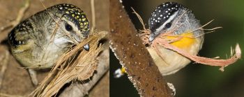
Note spot color on the heads.
Composite of two ChrisCharles Images
Photo © by
ChrisCharles Chatswood New South Wales,
Australia 3 September 2006
The female and male of this species can be determined, in part, by the color of the spots on their heads.
The female has yellow/creamy spots while the male has white spots.
See the composite image for further clarification.
References
- Embassy of the Republic of Indonesia - https://www.embassyofindonesia.org/index.php/basic-facts/
Recommended Citation
External Links
Maps
- Indonesia on Google Maps
Experiment With Dual Gsearch Coding


